Tech notes
Route Availability Planning Tool
A decision support technology that improves management of flight departures at airports during thunderstorms.
The Federal Aviation Administration (FAA) estimates that 70% of air traffic delays result from inclement weather. These delays translate into significant revenue losses for airlines. For example, a report from the U.S. Congress Joint Economic Committee concluded that air traffic delays cost U.S. airlines approximately $19.1 billion dollars in operating costs in 2007.1 Approximately two-thirds of weather-related delays are caused by thunderstorms (convective weather). While thunderstorms do not completely shut down the airspace, they significantly disrupt the structured flight-routing and control process that is the foundation of the U.S. air traffic control system.
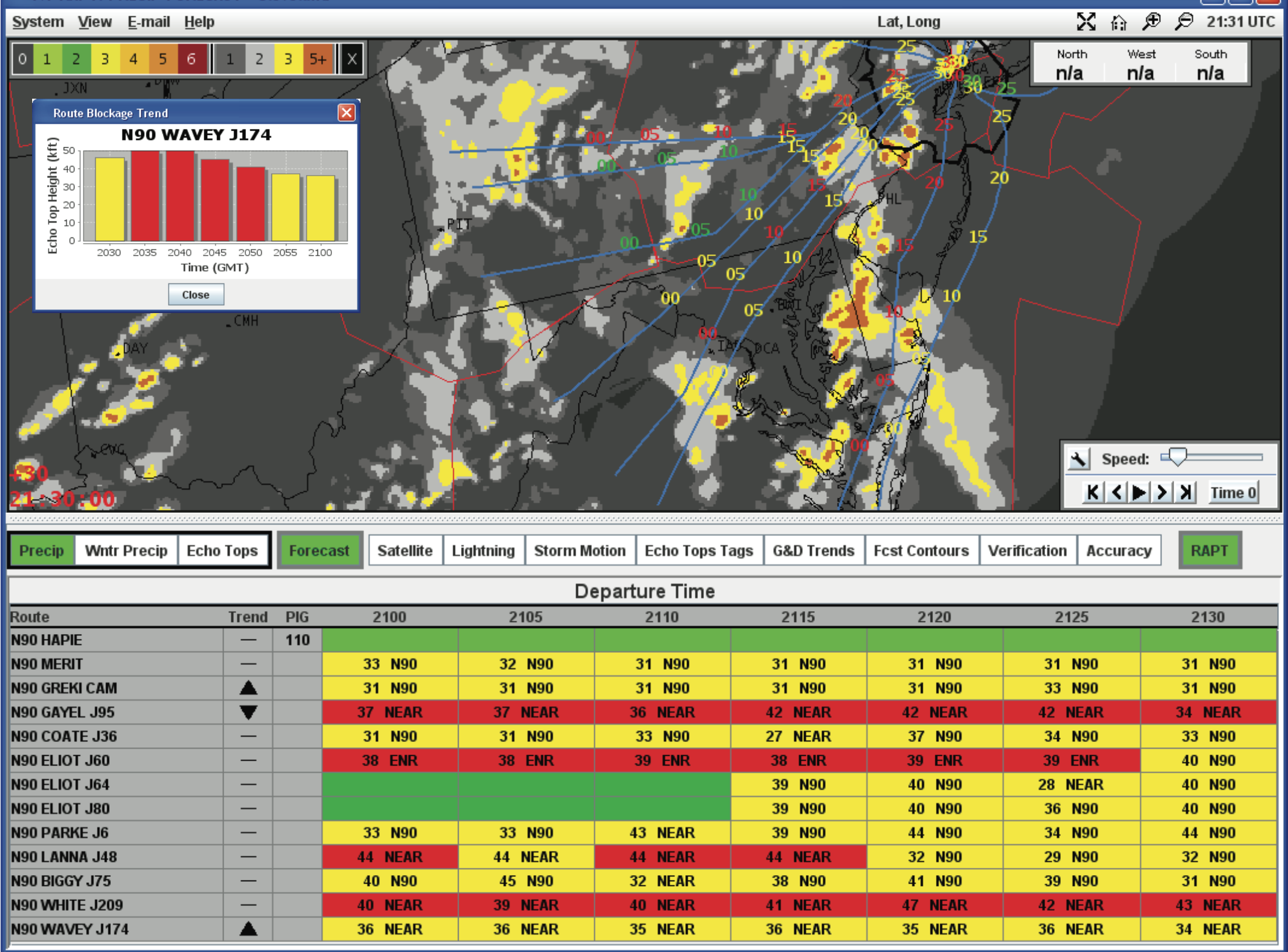 Route Availability Planning Tool display. The lower panel shows departure route timelines that indicate the impact of thunderstorms on specific routes in the next 30 minutes; the upper panel has an animated display of forecast weather with nominal departure trajectories overlaid.
To address the problem of costly delays triggered by thunderstorms, MIT Lincoln Laboratory developed a decision support tool that helps air traffic managers determine when to close and reopen departure routes during periods of convective weather. The Route Availability Planning Tool (RAPT) provides current, reliable route-availability information in a user-friendly format. Automated route conditions displayed on a data-rich interface help relieve the decision-making burden typically faced by air traffic managers—gathering weather information, mentally envisioning the repercussions of the weather data, rechecking for rapidly changing weather, and then deciding to allow aircraft to depart.
The RAPT concept was initially supported by the Port Authority of New York and New Jersey, and the FAA in 2007 established a program to field an operational prototype. Currently, RAPT is being used by airports in the New York/New Jersey and Chicago regions; RAPT is expected to be deployed to the Potomac and Philadelphia regions by 2015.
Improving departure rates
Often during periods of disruptive weather, air traffic managers concen- trate on landing the planes in the air and let departures wait at their gates. The backlog of departures builds, arrivals get caught in the traffic jam, and airline schedules downstream of the affected airport are pushed out because planes are not reaching their destinations.
While departure delays are a significant problem at all major airports, the congested airspace in the Northeast and upper Midwest United States is especially susceptible to long delays brought on by thunderstorms. The FAA estimates that one-third of all commercial airline flights daily pass through the New York airspace. Studies have shown that small increases in airport departure rates in the Northeast during severe weather could significantly reduce delays throughout the National Airspace System.2
RAPT improves departure rates by determining the specific routes and times that will be affected by operationally significant thunderstorm activity before a storm moves into a specific region. RAPT helps decrease weather-related departure delays and ground holding by providing air traffic managers with automated, objective guidance for
- Visualizing the impact of approaching weather systems
- Determining when to close and reopen departure routes
- Determining optimum departure routing on the basis of forecasts of convective weather
- Determining when to allow limited route usage during thunderstorms
Concept
RAPT integrates several algorithms for objectively predicting convective weather impacts on departure routes with an interface tailored to provide quick decision support to air traffic managers. The algorithms translate high-resolution, deterministic forecasts of precipitation intensity and storm height from the FAA's Corridor Integrated Weather System (CIWS) into probabilities that airspace affected by thunderstorms will be passable. This forecast of airspace availability is combined with a model for departure route usage that incorporates both statistically averaged flight trajectories and observed air traffic control tolerance for the deviations pilots make to avoid weather.
RAPT automatically calculates and assigns a route-blockage status color—red (blocked), yellow (partial or uncertain blockage), dark green (insignificant weather encountered), or green (clear)—to each planned route for departure times up to 30 minutes into the future. The RAPT user interface displays RAPT timelines and a weather animation window. Each row of the timeline display corresponds to a departure route. Each column corresponds to a future departure time, starting at the current time and extending out 30 minutes into the future in 5-minute intervals. The color of each timeline bin represents the departure status. Yellow and red bins have text annotations giving the trajectory phase and the echo-top (a radar-indicated "top" of a storm) height at the blockage location. The animation window overlays predicted locations of departing aircraft on forecasts of weather events.
Using RAPT guidance, air traffic managers can quickly determine if and when specific routes are free of serious weather impacts and available for use. A prompt decision is important. At major New York airports, 40 or more flights may be scheduled for departure in a typical 30-minute window; at an airport like O'Hare in Chicago, as many as 60 departures may be scheduled in a 30-minute period.
RAPT is distributed to the various participants in the departure management process (air traffic managers at airport control towers, FAA centers, and operations centers for major airlines in the region) to reduce the effort needed to coordinate decisions and to enable proactive decisions by participants in the chain.
Positive results from RAPT usage
RAPT improves the traditional method for determining when to allow limited route usage during thunderstorms, how to reroute air traffic, and when to reopen routes closed because of severe weather. Standard practice that relied on human judgment had resulted in an approach that fostered overly cautious decisions, leading to longer delays in getting air traffic flowing again. RAPT's objective determinations, backed by CIWS data, allow managers to make informed, timely decisions. Moreover, managers at different regional facilities equipped with RAPT have a common set of determinations that can be used for coordinated route management.
Studies carried out by Lincoln Laboratory and FAA personnel at New York airports using prototype RAPT systems during convective weather concluded that reductions in hours of departure delay can be realized by utilizing RAPT.3 The amount of time saved at an airport varied over the days on which assessments were made, ranging from modest savings of under an hour to slightly more than 10 hours. The study team, using an FAA standard calculation, translated these time savings into operational cost savings for the airlines and passenger "value time." For example, on one August 2007 day at Newark Liberty International Airport, $58,000+ in operating costs and passenger value time could have been saved through reducing downtime for departing aircraft.
As users became more comfortable with the RAPT prototype, they began to change their procedures for reopening departure routes. Prior to RAPT, departure managers relied on "pathfinders"—pilots who volunteered to fly not-yet-reopened routes to test if the routes could be reopened. Coordinating pathfinder activity and waiting for the pathfinder report takes as long as 60 to 90 minutes, keeping potentially available routes closed until pilots finally report back. Reopening routes based on RAPT's status data has reduced the use of pathfinders, replacing that approach with more efficient, proactive planning.
Furthermore, traffic managers have begun to reopen closed routes when they see that the "partial route blockage" (yellow) status is accompanied by improving weather-impact trends, indicating an imminent post-storm "route clear" (green) status. This trend was first noticed in summer 2009, when routes were reopened prior to the appearance of a post-storm "green" in 23% of the cases, and in 2010, the "reopen-prior-to-green" percentage increased to 35%.
By facilitating the timely reopening of routes and alleviating airport departure backlogs, RAPT is enabling substantial reductions in airline operating costs, in financial losses experienced by air-travel-associated businesses, and in passengers' wait time.
Posted 2012
1 "Your Flight Has Been Delayed Again," Report by the Joint Economic Committee Majority Staff, May 2008.
2 S. Allen, S.G. Gaddy, and J.E. Evans, "Delay Causality and Reduction at New York Airports Using Terminal Weather Information Systems," Project Report ATC- 291, MIT Lincoln Laboratory, 2001.
3 M. Robinson, R. DeLaura, J.E. Evans, and S. McGettigan, "Operational Usage of the Route Availability Planning Tool during the 2007 Convective Weather Season," American Meteorological Society, 2008.