Publications
Lab Notes
|
Untangling the Friendly Skies
Computer recommendations could clear up some weather-caused airline delays.
You've just finished a day of meetings in Washington, D.C. You arrive at Reagan National Airport in time for the 4:45 p.m. shuttle to Boston, only to discover that your flight is delayed—indefinitely—because of thunderstorms. The storms, however, are not in Boston or Washington, but in New York, and they've left the airplane that was supposed to take you to Boston stranded at LaGuardia.
Studies at Lincoln Laboratory suggest that getting even two or three additional flights per hour out of airports during thunderstorms in highly congested areas can significantly reduce the weather-related delays that ripple across the nation's air travel system. Laboratory researchers are developing a computerized prediction model and graphic display that can increase the odds of sneaking a few jets out between thunderheads.
Richard DeLaura of the Laboratory's Weather Sensing Group is working on the Route Availability Planning Tool (RAPT) to give air traffic managers assistance in deciding whether to allow planes to take off during inclement weather. The computerized tool takes weather information from satellites and radar systems, makes predictions about whether a pilot would choose to fly through such conditions, and displays the information graphically to enable an air traffic controller to make a quick decision.
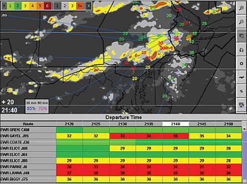 A screen shot of RAPT user interface shows the departure status timelines for Newark, N.J., departure routes and the weather forecast and projected departure trajectory animation screen. To help users understand the RAPT guidance, red and yellow departures in the timeline include the height of the echo tops encountered. Specific departures in the animation frame are color coded to match their departure status.
The display shows a map of the airport with lines radiating outward to indicate the various departure routes. A grid below the map lists departure times in rows, which are divided into columns of five minutes running from the present to half an hour in the future. Each rectangle on the grid displays a color that tells whether departure at that time along that route seems feasible. Red means the route is blocked. Yellow means there's some heavy weather that might pose problems. Dark green says there's weather, but that it shouldn't be an issue. Light green represents clear sailing.
Generally, air traffic managers get weather information and have to come up with a picture in their heads such as the one RAPT displays, then make decisions based on that mental image. If the weather is changing rapidly and there are a lot of flights in the air, the process of conjuring such a picture can become so time consuming that controllers decide not to let any flights out. Instead, they concentrate on landing the ones in the air. But if too many departures are stuck at their gates, the arriving aircraft have no place to go once they land. The result is a major traffic jam. DeLaura hopes that RAPT will take away some of the managers' burden, making more departures possible and thus minimizing delays.
"What they really need to know is the following: When can I start moving departures along this route? At what rate?" DeLaura says. "We can say, 'We think you can start limited departures in about 15 minutes and go to full capacity in 30.'"
RAPT bases its guidance on a computer model that combines the departure route geometry, forecasts for precipitation intensity and the height of radar echo tops (a measure of storm height), and a model for pilot behavior in convective weather (e.g., thunderstorms). The model estimates the probability that pilots will deviate significantly to avoid the weather along their routes and assigns the departure route status color based on that probability. The pilot model is based on studies of pilot behavior and other data gathered by DeLaura's group. "We're building the models from what we observe," DeLaura says.
A prototype of the system has been used in the New York City region—including LaGuardia, JFK, and Newark airports; several regional air traffic control centers; and commercial airline dispatch operations—for about four years, with modest funding from the Port Authority of New York and New Jersey. With 10,000 flights a day, it's among the busiest areas of the country.
This past year, the FAA began funding RAPT and asked for a major field assessment of the system. DeLaura and his colleagues spent the summer looking at how the system was performing. While they made some adjustments to the computer algorithms, their biggest discovery had to do with human factors. The air traffic managers using the system wanted to be sure they could trust what RAPT was telling them and needed to know why it was making certain predictions. For instance, managers trying to decide whether to release departures along a yellow route looked at estimated heights of cloud tops in the RAPT timeline display to help them decide what to do. When they noticed that those heights were low enough that pilots could safely fly over the storm, they were able to make an informed judgment about the best course of action. RAPT also includes an animation of how storm systems intersect with flights. Managers can glance at that to confirm that they're getting a green or yellow light because the storm is moving away from their flight routes.
In their study, the researchers found that RAPT reduced flight delays in 2007 by 2300 hours. In terms of the costs of operating aircraft, plus the value of passengers' time, that delay reduction saved $7.5 million. They estimate that fully implementing RAPT in the New York region could save 8800 hours per year, which translates
to $28 million in costs saved. "It certainly provides us with exceptional benefits in most scenarios with severe weather," says Leo Prusak, the FAA district manager for
the New York area. "I think it's a fabulous product."
The researchers are adjusting the model to take more account of the impact of arrivals on the system. Because incoming planes often avoid storms by deviating into the airspace used for departures, too many additional arrivals can disrupt or even stop departures altogether. The Lincoln laboratory group is also working on picking a site for the deployment of a second prototype system.
Eventually, DeLaura would like to see the system deployed at other large airports where congestion and convection cause major problems. Placing RAPT at key spots could reduce delays at both large and small airports all over the country, he says. "You wouldn't need to have it in Elmira in order for passengers in Elmira to see some benefit."
top of page