Foul Weather Friend
The Corridor Integrated Weather System now covers the continental U.S., expanding air traffic planners' and airline dispatchers' view of the nation's weather.
Weather prediction software developed at Lincoln Laboratory may help to ease delays in the nation's air traffic now that the Corridor Integrated Weather System (CIWS) has gone from a regional experiment to a continent-spanning demonstration project.
On June 3, CIWS, which provides FAA air traffic managers and airline dispatchers with predictions of the location and intensity of storms at airports and along airline routes, expanded its coverage to encompass the entire continental United States and the southern part of Canada.
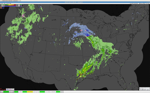
A November CIWS display shows snow (blue), ice (pink) and rain (green). This time 0 frame is the start of the winter weather forecast animation, which extends to two hours, looping in five-minute forecast increments; the entire forecast suite updates every five minutes. During the weather event shown, the CIWS forecasts enabled Northwest Airlines to collaborate with national and regional air traffic managers to develop a plan for when the passage of a heavy snow band would require a reduction in arrival rates at the Minneapolis-St. Paul airport. Knowledge of the snowfall's start time and duration allowed traffic managers to reduce airport demand, thus preventing excessive airborne holding and increased fuel usage.
"The fact that we've expanded the coverage of the CIWS products has helped greatly," says Michael McKinney, CIWS program manager at the Federal Aviation Administration (FAA), which sponsors the project. He says with partial coverage, traffic managers could only see how weather would affect flights in a particular region of the country. The updated system gives a more complete picture. "The CIWS expansion gives air traffic management personnel that had been outside, or on the boundary of the coverage area the ability to more fully assess how weather is going to affect their airspace," McKinney says. As any frequent flier knows, passengers can be sitting in one airport on a perfectly sunny day waiting for a plane that has been delayed because of thunderstorms elsewhere in the country. "The nation’s airspace is an enormous, interdependent network, so what happens in one location can affect operations in a very wide area," says Elizabeth Ducot, a senior staff member in the Laboratory's Weather Sensing Group and leader of the CIWS project. For example, when convective weather occurs in Ohio, the air traffic from the western states headed for the New York, Boston, and Philadelphia airports may need to be rerouted north into Canada or south through Georgia, causing delays in Atlanta even though the entire Atlanta area is completely clear. "Severe weather can cripple the flow of traffic nationwide," Ducot says.
Delays have increased in recent years, as propeller airplanes that fly at lower altitudes have been replaced with jet planes, making the higher altitudes more crowded. An increase in corporate jets has also added to the congestion.
Daily planning for the nation's air traffic has traditionally relied on highly inaccurate weather forecasts that cover two to six hours in the future. So the CIWS project was started in 2001 with the aim of providing forecasts in the zero-to-two-hour range that are updated every five minutes. These forecasts provide air traffic personnel a much more detailed picture of how weather is changing in ways that could affect flight plans, not only for take-off and landing, but also along the routes between airports.
CIWS provides forecasts of both precipitation and echo tops, which are the uppermost limits of the storms as measured by radar. Ducot says that previous forecast systems didn't look at echo tops, which are important in determining whether an airplane can fly over a storm. Additionally, CIWS forecasts whether the precipitation will be in the form of rain, snow, or a mixture, information that is particularly important in managing winter operations. Snow, for example, curtails visibility much more severely than the same amount of rain, so knowing when heavy bands of snow will arrive or depart in a terminal area is extremely valuable in trying to juggle arrivals and departures and keeping the airport open through a winter storm.
The Lincoln Laboratory team began testing the system in the Northeast Corridor and along the Great Lakes in 2001 because those were the areas that are most congested, even in good weather. Over the years, the team collected data and refined the system on the basis of feedback from FAA air traffic managers and the airlines. A study in 2005 found that the use of CIWS reduced delays that year by a total of 90,000 hours, resulting in a savings in airline operations cost of more than $90 million.
Providing nationwide coverage required an overhaul of the system. The coverage area more than tripled, which Ducot says led to a significant increase in the number of computations required. To be able to create these larger products quickly, software designers broke up the grid into smaller sections, called tiles, so weather predictions could be run simultaneously on several sections and then stitched back together into a whole. Programmers also needed to change some underlying assumptions. While on a smaller scale they could treat the Earth as if it were flat, there's enough curvature over the expanse of the U.S. that continuing to do that would introduce unacceptable errors into the predictions. So they adopted a nationwide standard mapping system that minimized the prediction errors and retested the software against it. "The re-engineering was a fairly major undertaking," Ducot says. In the process, the team took the opportunity to remove redundant sections of code that were the result of the evolution of the prototype in support of various research ideas along the way and rewrite bits of old software that had been designed to run on the obsolete systems in the original CIWS prototype.
The Lincoln Laboratory group also had to upgrade the computer hardware. The old system consisted of different types of computers, mostly a mix of Sun computers purchased between 2001 and 2003. At the heart of the upgraded system is a new 150-node Linux cluster of processors. Each node is a Dell PowerEdge 1955 Blade with two dual-core 2.9 GHz processors, 8 gigabytes of memory, and dual gigabit Ethernet connections. The system is designed to easily scale up to accommodate advances in the forecasting science that will lead to new capabilities for the FAA. The team also upgraded the phone lines connecting the computing cluster to the airports where dedicated CIWS displays show air traffic managers their data.
When the nationwide system was unveiled, it did not include the precipitation phase part of the product suite, since this wasn't needed in the summer. This feature was added in mid-November, just in time for winter. Dedicated CIWS displays have been installed in key air traffic facilities—primarily those in the heavily congested Northeast Corridor. But access to a website that provides the same information is available, upon request, to air traffic management personnel at air traffic facilities in other regions, as well as to the airlines. McKinney says air traffic managers around the country have been requesting accounts that give them access to the website, suggesting that they find the CIWS information useful.
Ducot says that while there are no measurements so far of the impact of nationwide coverage on air traffic operations, anecdotal evidence suggests that the upgraded system is helping to reduce delays. Over the next few years, Lincoln Laboratory will continue operating, monitoring, and upgrading CIWS, which is still considered a prototype.
In 2011, the FAA is planning to transition the system to the agency's William J. Hughes technical center in Atlantic City, N.J., with help from Lincoln Laboratory. At that point, CIWS will no longer be operated by the Laboratory as a prototype, but will become recognized as a formal part of the U.S. National Airspace System, which handles the flow of the nation's air traffic.
|